ARBEIA
The Wall ended at Wallsend. Its eastern supply route came through the sea — where the empire's far edges met at the mouth of an English river.
The way in
The curtain of Hadrian's Wall runs out at Segedunum — Wallsend, on the north bank of the Tyne. E1 Arbeia lies across the river mouth, on the south bank, a little downstream.
It was never a continuation of the barrier. E1 It was the thing a wall of stone could not be: a way in. Where the Wall was a closed edge, Arbeia was an opening — the point where the sea road met the land frontier, where ships, grain, orders and people crossed from the water into the Wall zone.
To stand here is to see the frontier differently. Not a single line drawn across the neck of Britain, but a system with a mouth — and the mouth faced the sea.
Three centuries, many purposes
It stands on the Lawe — a headland of magnesian limestone above the Tyne mouth, with a long grey view out to the North Sea. E1
Whoever held this ground watched the sea approach to the river, and through it the eastern end of the frontier. The fort did not grow all at once; it was rebuilt and repurposed across three centuries. It was a garrison, but supply became its defining work.
There is a timber fort early in the second century, and there is Hadrian's Wall. There is no inscription, and no excavated proof, that ties Arbeia's foundation to Hadrian himself. The connection is structural and strategic — the same frontier, the same need — not personal.
A ledger with a river running through it
Early in the third century the fort was rebuilt around a new priority: storage and supply.
The interior was cleared and filled with rows of stone granaries; the fort was pushed south and reorganised as a supply base. This was Severan work, around AD 205–210, feeding the campaigns into Scotland and the garrisons of the Wall. Lead sealings from the imperial household came out of this ground — the baggage of an empire at war, tagged and counted. The frontier did not run on glory. It ran on bread, and bread had to be carried.
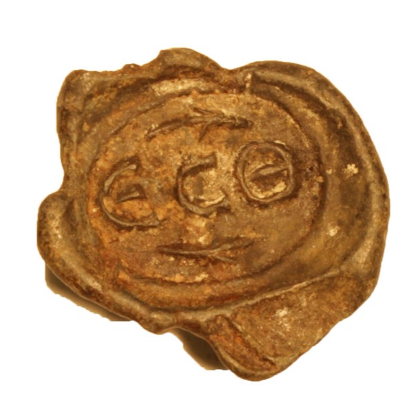
Greek-East stamp · PAS NCL-381163
CC BY-SA 4.0 · PAS / Trustees of the British Museum
Lead sealings of the imperial household came out of this ground — the baggage of a campaigning emperor, tagged and counted through this store. E1
The great granary supply-base is mainly early third century, Severan — not Hadrianic. North East Museums records thirteen stone granaries from AD 205–7, then seven more during the Scottish campaigns: twenty in that official sequence, a century after the Wall was first drawn.
Two voices, one stone
The most human object from Roman South Shields is the tombstone a Syrian set up for his British wife — and he could not say goodbye in one language alone.
One woman · two languages · the desert and the North Sea, cut into the same slab.
A man of the desert caravan-city, most likely a trader or army supplier — who carried his alphabet two and a half thousand miles and used it, once, in grief. E1
The inscription names Victor, aged 20, as the freedman of Numerianus, a trooper in the First Cavalry Regiment of Asturians. “Moorish” is usually read as a North African identity without forcing a modern category onto it. E1 RIB 1064
The late garrison included boatmen from the Tigris region. North East Museums records that the fort was then given the name Arbeia, meaning “the place of the Arabs.” E1
The name "Arbeia" is late and slippery — recorded long after Hadrian — and the precise origin of any one person should be held lightly; the Latin records what the carver chose to record. What is certain is the shape of the place: a watery, cosmopolitan crossing. Regina is also the direct bridge to Women of the Wall.
The world outside the gate
A fort is only the hard centre of a settlement. Around Arbeia, as around every Wall fort, there was a vicus.
A civilian town of traders and craftspeople, soldiers' partners and children, freed and enslaved people — and local Britons who had lived on these river banks long before the army came. E2 The tombstones of Regina and Victor are the clearest sign of it: families, dependants and freed people, living their lives outside the wire.
Goods, supply and movement connected the fort to river and road.
Partners, children and dependants lived beyond the military plan.
Regina and Victor make unequal Roman lives visible by name.
The Lawe was lived on centuries before the army arrived.
This is where the page could become powerful — and where it could over-romanticise. The vicus evidence is patchy and disturbed by the modern town. We sketch it from the tombstones and the wider Wall pattern, not a fully excavated street. Q
Grain by the shipload — and everything else
Feeding a supply base meant animal bone, amphorae for oil and wine and fish sauce, and the produce of local farms — meat, milk, hides, fodder. E2 For the texture of how frontier supply actually worked — the cash, the hides, the carts, the bad roads, the worry over the animals — the writing tablets from Vindolanda are the best witness we have, though they belong to the wider frontier, not to Arbeia itself. comparative
The Tyne was a working river of mud, boats and cargo. But the archaeology that would let us describe Roman Arbeia's river economy in detail — fish bones, shellfish, nets or a built harbour — is not yet in hand. A port function is clear from the fort's job and position; a large excavated quay or basin is not. We treat the fishing river as a question, not a fact. Q
A web of water and road
Arbeia was a node in a network, not a lonely outpost. E2
Upriver lay Segedunum and the Wall; the Tyne itself was a road. South, across the next headland, the River Wear carried its own Roman traffic — in 2026 a Roman-period industrial settlement was reported at Offerton on its banks, with pottery production and military-linked finds: a glimpse of how busy this coast and its rivers really were. E1 Inland, roads ran to the forts at Chester-le-Street, Lanchester and Binchester.
There may be no neat "next fort down the coast." The Roman world here was river, road, industry and farm — a working corridor — not a tidy line of coastal beacons. And Tynemouth, on the headland, was not an extension of the Wall. Q
The gaps, kept in plain sight
An honest page keeps its gaps together — not in every sentence, but here.